
Lofty Lake Loop – High Uintas
- igntranslations
- Jul 31, 2025
- 4 min read
Utah summers can be brutally hot, with temperatures often hitting the upper 90s and 100s (35-40 Celsius). Luckily, there’s one area that stays relatively cool, thanks to its sky-high elevation and it’s the perfect summer hiking escape.
The High Uintas, located in northeastern Utah about two hours from Salt Lake City, are a hiker’s dream. Mirror Lake Highway (Scenic Byway 150) winds through this alpine wonderland, connecting Kamas, Utah, to Evanston, Wyoming. The road closes in winter under deep snow and typically reopens in mid to late May, just in time for hiking season. Along the highway you’ll find crystalline alpine lakes, campgrounds, and trailheads galore. The Uintas are Utah’s highest mountain range, crowned by King’s Peak at 13,528 feet (4,123 m). Don’t worry... this blog isn’t about summiting that beast (it’s on my bucket list, though!).
Of Alpine Lakes and Meadows
We left our house in Ogden at 8 a.m. on a hot Sunday in July, hoping to snag a parking spot and beat the crowds. Our packs were loaded with water, electrolytes, healthy snacks, and a picnic lunch. Today’s mission: Lofty Lake Loop - a high-elevation trail in the Uinta-Wasatch-Cache National Forest that hops between gorgeous alpine lakes. It did not disappoint!
Since it’s a loop circling Scout Peak (11,113 ft / 3,387 m), you can hike it clockwise or counterclockwise. After a little AllTrails research, we decided to tackle the hike counterclockwise and I’m glad we did. I’m a “rip the Band-Aid off” kind of hiker: get the hard part done first. Hiking counterclockwise means a steep climb in the first 1.5 miles (2 km), followed by a more moderate descent through forests and meadows. Clockwise would have meant a long, gradual 3.5-mile (6 km) climb that feels like it never ends.
We reached the trailhead at 10 a.m. and lucked into the last spot in the small parking lot. Overflow parking is available along Mirror Lake Highway. There’s also a vault toilet and a couple of picnic benches.
Sunscreen? Check. Hats? Check. Backpacks on? Let’s go.
The Climb
The trail starts at 10,150 ft (3,094 m) and gains another 1,060 ft (323 m), so the air is thin from the get-go. The first stretch is a gentle walk through shady pines. Watch your step, exposed roots and rocks are eager to trip you up.


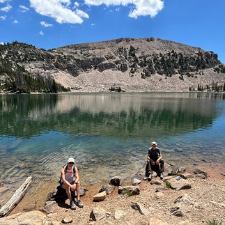
Soon we passed Picturesque Lake, a charming little pond true to its name. The trail then climbs to Scout Lake, a larger lake framed by alpine meadows on one side and forest on the other. Fish leapt from the water as we snacked and soaked in the view.
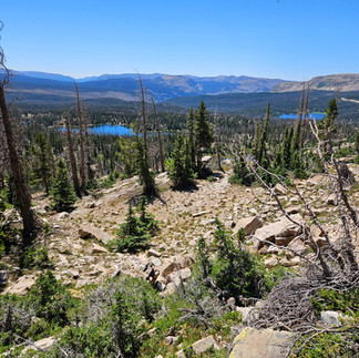
After Scout Lake, the real workout begins. The trail climbs steeply toward the treeline, trading shade for boulder fields and jaw-dropping vistas. My lungs and heart reminded me that, yes, I am a middle-aged woman, and yes, they were working hard 😊 The combination of views and exertion is literally breathtaking, so take your time.
The high point of the loop is at 10,890 ft (3,322 m), about 1.9 miles (3 km) in. Stop here to admire the sweeping views, you’ve earned it!


Lofty Lake and Beyond
From the rocky apex, the trail descends to the loop’s namesake, Lofty Lake. Small, serene, and absolutely photo-worthy.

The north side of Scout Peak offers magnificent vistas stretching to Wyoming. Below, you can spot Teal and Cutthroat Lakes. We skipped the detour this time, saving them for a future adventure.
The trail then wanders through a wildflower-dotted alpine meadow before ducking back into the pines. Soon you’ll reach Kamas Lake, an icy gem at the foot of a rock cliff. We paused for water and a chat with some overnight campers while a few anglers tried their luck.


From Kamas Lake, the trail winds through more forest. Watch for roots, loose rocks, and the occasional shallow stream crossing, though our feet stayed dry. A few muddy patches from recent rain were easy to sidestep.
We passed another lush meadow, where I was sure we’d spot deer or elk. Nope! Our only wildlife sightings were chipmunks and a family of ducks paddling in a pond.
The south side of the loop is mostly downhill, with one short uphill before the finish. By 1:30 p.m. we passed families just starting their clockwise hikes, while the sun and heat were ramping up. I was grateful for our mid-morning start, we beat both the crowds and the heat.
We returned to the car in under four hours, including breaks for snacks, photos, and breath-catching. According to AllTrails, this is a moderate hike and it gets all the stars from this hiker!
This may be my favorite High Uinta hike yet. I love loops over out-and-back trails, and this one had it all: lakes, meadows, forests, sweeping views, and a satisfying climb. I’d happily make this a summer tradition.


Logistics & Tips
Trailhead: located off Mirror Lake Highway (Scenic Byway 150). Look for “Pass Lake Trailhead Rd” across from Pass Lake. Coming from Kamas, it’s just past Mirror Lake.
Parking: small lot at the trailhead, plus roadside overflow.
Trail Directions:
Counterclockwise trailhead: northeast corner of the lot.
Clockwise trailhead: west side of the lot.
Distance: 5.5 miles (8.6 km) loop, 1,060 ft (323 m) elevation gain.
Gear: Sunscreen, sun protection, sturdy hiking shoes, backpack. I skipped poles and didn’t miss them.
Other essentials: Bug spray (mosquitos are huge!), water, and snacks.
Dogs: Allowed on leash.
Fees and permits: a National Park Pass covers the day-use fee. Or pay the $10 fee (good for 3 days)
Weather: Afternoon thunderstorms are common, check the forecast and be prepared.
Extended stay: There are plenty of camping spots along Mirror Lake Highway to pitch a tent or park your camper.
Leave No Trace: Pack it in, pack it out.
Think you’re ready to trade the city heat for some high-altitude adventure? Let me know if Lofty Lake Loop makes it onto your hiking list!


Comments